Explore Tours


Build your dream
experience

More to know about Sardis
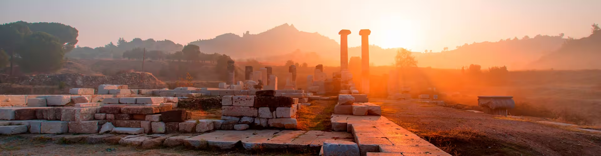
Discover Sardis ancient ruins and royal heritage in Türkiye
Sardis Travel Guide
Once a capital of the ancient kingdom of Lydia, Sardis is one of western Anatolia’s most atmospheric archaeological landscapes, where monumental ruins sit against the foothills of Mount Tmolus near the modern town of Sart. It is the kind of place that rewards slow travel: broad avenues of stone, temple columns catching the light, and museum displays that help you read the site like a story rather than a checklist.
This guide is designed to help you plan a high-confidence visit in Manisa Province, from logistics and pacing to the most meaningful on-site highlights. It also supports trip planning for travelers comparing regional routes through the Aegean and inland Türkiye.
Snapshot
Sardis feels like a layered time capsule: Lydian wealth, Persian and Hellenistic power, Roman civic grandeur, and later Byzantine traces all share the same valley floor. Visit for the scale, the open space, and the rare chance to see major structures without the crush you find at more famous coastal stops.
Why now? The Aegean interior is increasingly popular for culture-focused itineraries that blend archaeology with local landscapes, and this site slots easily into routes between İzmir, Manisa, and the wider region.
🗺️ Geography and Logistics
📍 Orientation:
This ancient city lies in Manisa Province in western Türkiye, near the modern settlement of Sart. The setting is a wide valley at the edge of the Aegean hinterland, making it a natural stop if you are traveling between İzmir and inland Anatolian towns.
Common gateways include İzmir’s main airport and intercity bus networks that connect İzmir, Manisa, and Salihli. From the nearest larger towns, travelers typically continue by taxi, private transfer, or rental car for the last stretch.
🕒 When to Go:
Spring and autumn are the sweet spot for walking among ruins, with mild temperatures and clearer light for photography. Summer can be hot and exposed on open stone surfaces, so aim for early morning visits and bring sun protection.
Winter is quieter and can be rewarding for travelers who prefer solitude, though weather may be cooler and occasionally wet. If you want a balanced experience with comfortable walking and fewer tour groups, shoulder-season weekdays are ideal.
⭐ Essential Things to Do
-
Explore the Roman-era gymnasium and bath complex
One of the most visually striking areas, this complex communicates how Roman civic life worked: fitness, bathing, and social rituals in a single monumental setting. Architectural fragments and reconstructed sections help you imagine the original height and ornamentation. Practical tip: arrive early for softer light and fewer people in your photos.
-
Walk the colonnaded avenue and urban core
Following the main street gives you an intuitive sense of city planning and daily movement, from public buildings to commercial zones. The experience is less about one “must-see” object and more about scale and continuity. Practical tip: wear shoes with grip, as polished stones and uneven paving can be slippery.
-
Visit the Temple of Artemis precinct
The temple area hints at the city’s religious importance and its long life across changing empires. Even in partial ruin, the surviving columns and foundations are powerful, especially when you pause to take in the surrounding landscape. Practical tip: build in time to circle the perimeter for different angles and a better sense of footprint.
-
Look for Lydian heritage and the story of ancient wealth
This region is famously associated with the Lydians and the legacy of prosperity that shaped its reputation in antiquity. Understanding that context makes the monumental architecture feel less abstract and more connected to real political and economic power. Practical tip: read interpretive panels carefully, they often provide the best quick context without needing a full guidebook.
-
Spend time in the on-site museum for context
Seeing inscriptions, small finds, and curated displays helps you connect the big stones outside with the people who lived here. Museums also clarify timelines, which can otherwise blur when multiple eras overlap in one place. Practical tip: start at the museum if you want the ruins to “make sense” immediately, or end there to consolidate what you just saw.
-
Photograph the site with the valley and foothills as backdrop
Part of the magic is the setting: wide skies, distant slopes, and a sense of openness that amplifies the ruins. The landscape also explains why the settlement thrived as a strategic and agricultural hub. Practical tip: late afternoon can bring warmer tones on stone, but plan your walking route so you are not rushing at the end.
-
Join a guided day tour for deeper interpretation
If you want more than surface-level sightseeing, a guide can connect architectural fragments to broader themes like Roman urbanism, Anatolian kingdoms, and regional trade routes. Guided visits also help you notice details you might otherwise pass by. Practical tip: book in advance during spring and autumn weekends, when demand tends to rise.
-
Pair the ruins with a regional Aegean archaeology route
This stop works well as part of a wider itinerary that includes nearby classical sites and museums across the Aegean region. It adds variety because it is inland and less crowded, with a different landscape feel than coastal ruins. Practical tip: if you are self-driving, plan fuel and snacks ahead, as rural stretches can be limited between towns.
🎟️ Planning Your Visit
Plan for a half day on site if you like to walk slowly, read signage, and take photos, or a shorter visit if you are on a tight regional loop. The terrain is mostly open-air with long, sun-exposed sections, so pacing and hydration matter as much as your route.
Ticketing and entry rules can change seasonally, so confirm official details close to your travel date. If you are combining multiple heritage stops in the region, consider whether a private transfer or guided tour will save time and reduce logistical friction.
What to bring: water, sun protection, comfortable shoes, and a light layer for shoulder seasons. If you are visiting in warmer months, prioritize early hours and take breaks in shaded areas where available.
🌿 The Natural and Historical Context
This part of western Anatolia sits at a crossroads between the Aegean coast and the interior, which helps explain the site’s long strategic value. Over centuries, different powers built, rebuilt, and repurposed the same urban footprint, leaving an unusually readable sequence of eras in one visit.
The surrounding valley landscape contributes to the experience: broad views, agricultural plains, and a sense of distance from the modern coastal resort corridor. That quieter setting makes it easier to imagine processions, civic gatherings, and everyday movement through the ancient streets.
Historically, the area is strongly associated with the Lydian kingdom and later Roman civic life, offering a compact way to understand how Anatolia connected to wider Mediterranean networks. Even without specialist knowledge, you can feel the shift from sacred precincts to public amenities as you move across the ruins.
🚌 Navigation and Transport
Most travelers reach the site by rental car, taxi, private transfer, or as part of a guided excursion from nearby cities in the Aegean region. Public transport can be possible via intercity buses to nearby towns, but last-mile connections may be limited and time-consuming.
On site, walking is the main mode of transport, with distances that can feel longer under strong sun. Accessibility varies due to uneven stone surfaces and archaeological terrain, so travelers with mobility needs may prefer a guided plan that prioritizes the most accessible viewpoints and key monuments.
For safety and comfort, carry water, watch your footing on ancient paving, and avoid climbing on ruins. If you are driving, keep an eye on rural road signage and download offline maps in advance for patchy coverage.
📍 Nearby Attractions
-
Salihli and local thermal areas
Travel time: roughly 15 to 30 minutes depending on where you start. Primary reason: a practical base for food, supplies, and a slower-paced local atmosphere after the archaeological visit.
-
Manisa city center
Travel time: roughly 1 to 1.5 hours. Primary reason: museums, Ottoman era heritage, and a deeper look at the province beyond the ruins.
-
İzmir
Travel time: roughly 1.5 to 2 hours. Primary reason: a major gateway with waterfront neighborhoods, food culture, and transport links for wider Aegean travel.
-
Aegean archaeological corridor (regional sites)
Travel time: varies by site. Primary reason: build a themed itinerary that compares inland and coastal classical heritage across western Türkiye.
✅ Insider Tips for Travellers
- Start early to avoid heat and to photograph major structures with softer light.
- Plan your route to alternate open areas with any shaded stops, especially in summer.
- Wear sturdy shoes, surfaces can be uneven and some stones are slick when polished or dusty.
- If you want deeper meaning, consider a guide or audio guide so the layers of history do not blur together.
- Carry water and basic snacks, rural options can be limited between towns.
- Be respectful around fragile remains, avoid climbing on walls or columns.
- Combine the visit with a wider Aegean itinerary to maximize travel time in the region.
❓ Frequently Asked Questions
How much time should I plan for the site?
Most travelers are comfortable with 2 to 4 hours, depending on how much you like to read signage and take photos. If you add the museum and prefer a slower pace, a half day is a better plan.
Is it better to visit independently or with a guide?
Independent visits are straightforward if you have your own transport and you are happy with basic interpretation from panels. A guide is worth it if you want the story behind the ruins and a more efficient route.
What is the best season to visit Sardis?
Spring and autumn are usually the most comfortable for walking, with mild temperatures and good light. Summer can be very hot on exposed stone, so go early and bring sun protection.
Can I combine Sardis with other places in the Aegean region?
Yes, it fits well into a western Türkiye archaeology loop, especially if you are moving between İzmir, Manisa, and nearby towns. The inland setting also adds variety compared with coastal heritage stops.
What should I pack for an open-air ruins visit?
Bring water, sun protection, and comfortable shoes with grip for uneven surfaces. A light layer helps in shoulder seasons, and offline maps can be useful on rural roads.
Located in Manisa Province in western Türkiye, the Sardis archaeological zone sits near the modern town of Sart, within reach of İzmir and regional Aegean transport routes. This guide focuses on practical planning, on-site priorities, and nearby extensions for culture-led itineraries. This guide was curated by Toursxplorer.com to help travelers navigate this destination with confidence.
Asia > Turkey Republic of Turkey > Aegean Region > Manisa Province > Sardis