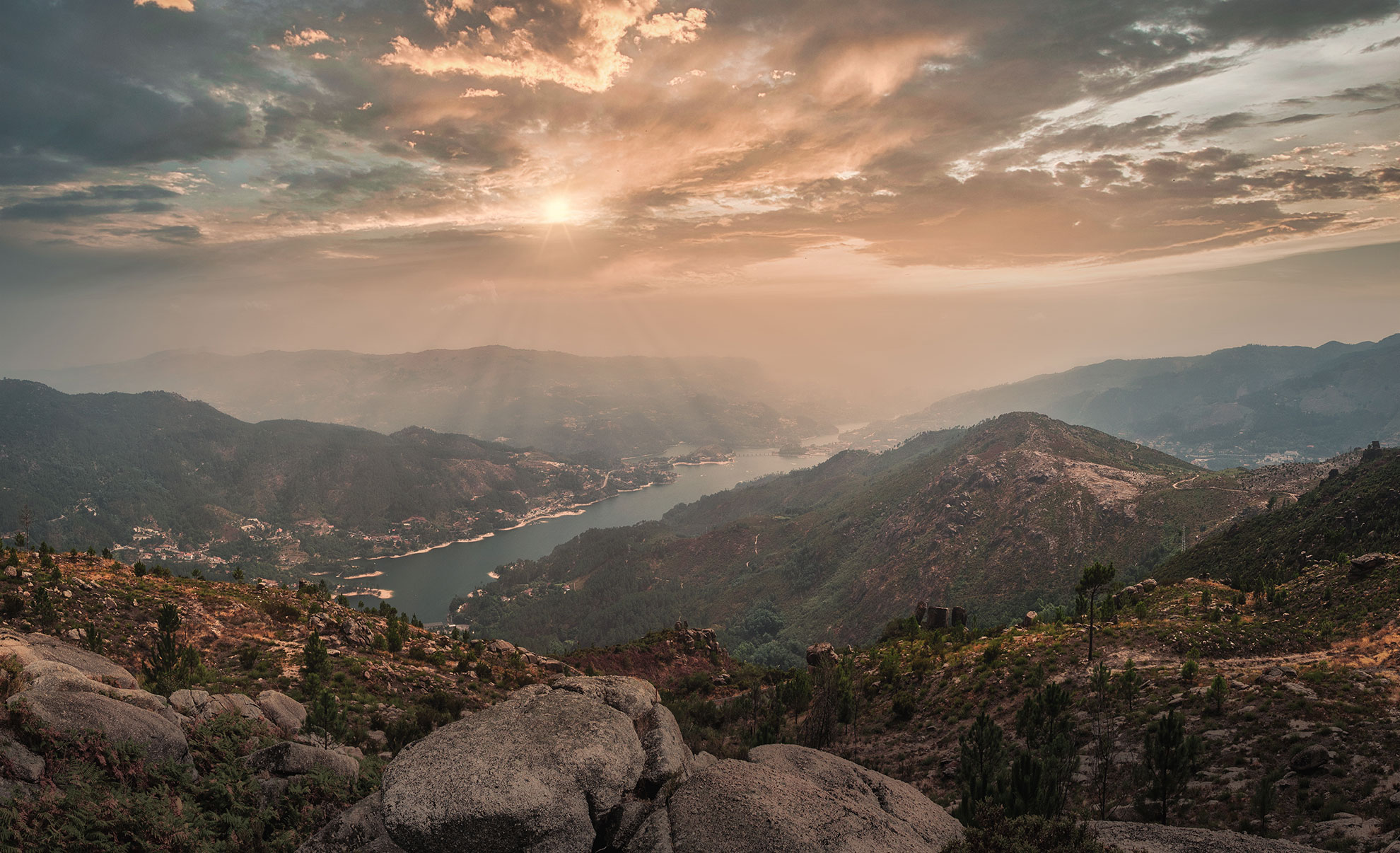
Morning mist settles over the jagged skyline of Peneda-Gerês, Portugal's only national park.
Portugal's Wild Heart
Granite, Water, and Myth: A Guide to the Untamed Beauty of Peneda-Gerês
Where ancient Roman roads disappear into oak forest, Garrano horses roam free across the moors, and moss-covered stones hold the memory of two thousand years of mountain life.
Portugal's northwest corner conceals a landscape that operates entirely on its own terms. Peneda-Gerês National Park — the country's sole national park, established in 1971 — sprawls across roughly 70,000 hectares of granite peaks, river gorges, and upland heath straddling the Spanish border. It does not perform for visitors. The waterfalls roar regardless of whether anyone is watching. The mist-shrouded summits shift and disappear without warning. The Iberian wolf passes at night and leaves only tracks in the morning mud. This is a place that demands presence, not passive sightseeing.
The park encompasses four distinct mountain ranges — Serra da Peneda, Serra do Soajo, Serra Amarela, and Serra do Gerês — each with its own character, each layered with evidence of continuous human habitation stretching back to the Neolithic. The tension between wilderness and settled life is what makes Gerês genuinely singular. Granite espigueiros (raised stone granaries) stand in medieval villages as they have for centuries. Ancient shepherds' paths wind across ridgelines used long before the Romans arrived and inscribed their own passage in stone. Understanding the park means reading both registers at once: the wild and the deeply, stubbornly human.
"In Gerês, the stones remember everything. The Romans paved this ground. The shepherds wore it smooth. The river, eventually, will take it all back."
The Waters: Lagoons, Cascades, and the Rivers That Shape Everything
Water is the park's defining element — the force that carved its valleys, filled its reservoirs, and gives the landscape its characteristic luminous green. The lagoons of the high serra, including Lagoa do Marinho and the cluster of mountain lakes accessible on the Seven Lagoons route, sit in glacially scoured bowls at elevation, their surfaces shifting from slate-grey to deep emerald depending on the light and season. On a clear morning in April, the reflections of the surrounding heath in these still pools are disorienting in their clarity.
The waterfalls are more theatrical. The Cascatas do Arado, reached via a walking trail through ancient oak woodland near Ermida, drop in a series of tiers into dark, cold plunge pools. Portela do Homem, on the Spanish border, combines a roaring cascade with the remains of the Roman road — milestones still upright in the forest, worn smooth but legible, the Latin inscriptions recording distances in Roman miles as if the empire were merely on a brief interruption. The Cascatas do Tahiti, near the main Gerês village, are the most visited and therefore the least solitary, but the surrounding schist canyon justifies the short walk from the road.
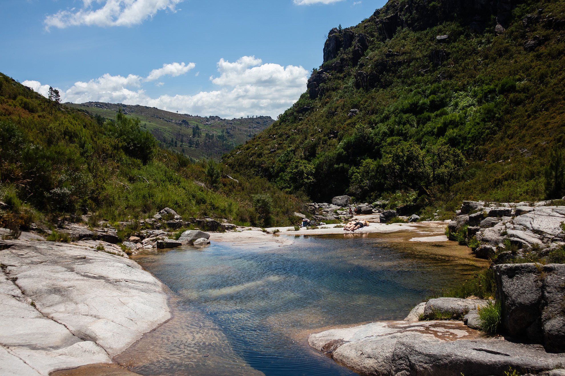
The Seven Lagoons route crosses high moorland before descending to a series of glacially formed lakes.
Day Trips & Full-Day Tours from Porto
The Villages: Granite, Espigueiros, and the Weight of Continuity
The human settlements of the park are not reconstructed heritage sites — they are functioning communities, some now reduced to a handful of residents, built entirely from local granite and governed by a logic that predates the nation-state. Soajo and Lindoso are the most frequently visited. Both are situated in the Serra do Soajo and reached by roads that wind through terraced hillsides of maize and vine. What draws visitors to both villages are the communal espigueiros: rows of elevated stone granaries, raised on mushroom-shaped supports to discourage rodents, their rooflines topped with stone crosses. Lindoso has 22 of them, clustered beside a medieval castle on a promontory above the Lima valley. In late summer, when the maize is stacked inside and the surrounding countryside is golden, the scene achieves an almost ceremonial gravity.
Further north, in the Serra da Peneda, the sanctuary of Nossa Senhora da Peneda occupies a baroque staircase setting that recalls Bom Jesus do Monte in Braga but without the crowds. Pilgrims climb the granite steps on their knees in September, and the village below the sanctuary retains a feudal stillness for most of the year. The drive to reach it — through narrow roads above the Peneda gorge, past hamlets where elderly women still carry firewood in wicker baskets — is itself an education in how remote and how persistent these communities remain.
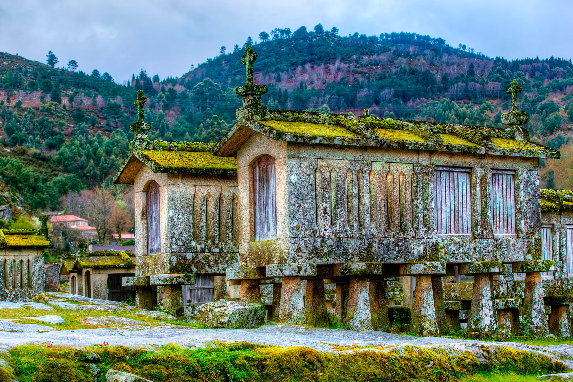
The espigueiros of Lindoso — communal granaries used by the village for centuries — stand beside a 13th-century castle above the Lima valley.
"The espigueiros of Soajo and Lindoso are not monuments. They are still being used. The past here is not behind glass."
Multi-Day Private Tours
From a single day trip out of Porto to a three-day private circuit of all four mountain ranges, there are itineraries for every pace and interest. Browse all available Peneda-Gerês tours and check current availability.
See all Peneda-Gerês tours →The Roman Legacy: The Geira and Its Milestones
The Via Nova — known locally as the Geira — was the Roman road connecting Bracara Augusta (present-day Braga) to Asturica Augusta (Astorga, in Spain). Sections of it survive within the park in a state of remarkable preservation, most notably near Portela do Homem on the northern edge of the Caniçada reservoir. Here, original paving stones remain underfoot, and dozens of milestones — cylindrical granite columns inscribed with the names of emperors and distances — stand at irregular intervals along the route, some tilted, some fallen, all worn by two millennia of weather. Walking this stretch of the Geira is one of the park's more quietly affecting experiences: the forest is dense oak and birch, the path runs beside a stream, and the milestones appear without announcement, as if the road's builders simply stepped away and will be back shortly.
The Geira also functions as a long-distance hiking route today, and sections of it can be incorporated into day walks from Caldas do Gerês or combined with the waterfall trails at Portela do Homem. For those travelling by 4x4 or with a guide who knows the unmarked tracks, the Miradouro da Pedra Bela — a high granite outcrop above the treeline — offers one of the park's most unobstructed panoramas across the Serra do Gerês toward Spain, particularly at dusk when the light becomes horizontal and the granite turns amber.
Wildlife and the Living Landscape
The park's wildlife inventory includes species that have disappeared from most of Western Europe. The Iberian wolf persists in the park's more remote sectors, though sightings are rare and generally require patience, early starts, and luck in equal measure. More accessible are the Garranos — the semi-wild horses of Gerês, a pre-Roman breed of small, hardy mountain ponies that roam in groups across the upland plateaus. They are not domesticated and not entirely wild; they have grazed these moors in this ambiguous middle state for as long as the villages below them have grown grain. Red deer are visible at dawn in the valleys of the Serra Amarela, and in autumn the sound of stags calling across the misty hillsides carries for considerable distances. Golden eagles and short-toed snake eagles patrol the ridgelines. The rivers hold native trout and the endemic Iberian endemic freshwater species that make the park's river system of conservation significance beyond its borders.
Adventure & Water-Based Tours
Whether the draw is ancient roads, granite villages, mountain lagoons, or the river system from a kayak, Peneda-Gerês rewards time and attention. All tours below include local guides with deep knowledge of both the natural and cultural landscape.
Browse all available tours →Frequently Asked Questions
How far is Peneda-Gerês National Park from Porto?
The main Gerês village is approximately 100 km northeast of Porto, around 1.5 to 2 hours by car depending on traffic and the specific destination within the park. The northern Peneda sector is roughly 130 km from Porto. Most organised tours include transport from Porto.
What is the best time of year to visit?
Spring (March to May) offers the highest water levels in the lagoons and waterfalls, green landscapes, and manageable temperatures for hiking. Autumn (September to November) brings deer rut, golden foliage in the oak forests, and fewer visitors than summer. Winter is cold and sometimes snowy at altitude but can produce dramatic misty conditions.
Are the granite villages of Soajo and Lindoso accessible on a day trip from Porto?
Both are reachable on a long day trip, though the drive from Porto to the northern Peneda sector takes closer to 2 hours. A two-day itinerary allows more time in the villages without rushing. Guided private tours covering both the Gerês and Peneda areas typically recommend at least two days.
Do I need to be physically fit to visit the park?
The park accommodates a range of activity levels. Many of the key waterfalls and viewpoints are accessible by car or short walk. The Seven Lagoons route and multi-day hiking trails require reasonable fitness and appropriate footwear. Kayak tours are generally suitable for beginners in calm water conditions.
Is it possible to see Garrano horses in the wild?
Yes. The Garranos are most commonly encountered on the high plateaus of the Serra do Gerês and Serra da Peneda, particularly between Fafião and the Mourela plateau. They are semi-wild and generally unbothered by human presence at a respectful distance. A guide familiar with their current grazing areas significantly improves the chances of a sighting.
What is the Geira and how do I access it?
The Geira is the surviving section of the Roman Via Nova road within the park. The most accessible stretch, with standing milestones, runs near Portela do Homem at the northern end of the Caniçada reservoir. It can be walked independently or incorporated into a guided tour of the park's northern sector. The milestones are unenclosed and free to visit.