
Garfield County is a wide-open slice of southern Utah where scenic drives, small-town gateways, and high-desert silence set the pace. The area is defined by big sky viewpoints, rugged public lands, and a road-trip rhythm that rewards early starts and slow afternoons. Use this guide to plan routes, choose seasons, and build an itinerary that fits your energy level and comfort with remote travel.
Garfield County feels like Utah on a grand scale, long horizons, dark night skies, and landscapes that shift quickly from forested high country to red rock country. Go now if you want space, scenic drives, and a destination that still feels uncrowded once you leave the main corridors. The signature vibe is adventurous but grounded, you can chase viewpoints all day, then reset in a quiet town at night.
Garfield County sits in southern Utah in the United States, positioned between major national park regions and expansive public lands. Most travelers approach by road from larger hubs in Utah, Arizona, or Nevada, then use a base town to branch out to scenic routes and trailheads. For flights, look at major gateway airports in the region, then plan a rental car, because driving is the practical way to connect the county’s spread-out highlights.
Seasonality in Garfield County is about elevation and exposure. Warmer months bring longer days for scenic drives and hiking, but also stronger sun and the highest visitor demand on the most famous routes. Shoulder seasons often feel more balanced for comfort and crowd levels, with crisp mornings and calmer roads. Winter travel can be rewarding for solitude and dramatic skies, but conditions can vary by elevation, so build flexibility into your plan.
Currency is the US dollar, and costs typically reflect a road-trip destination where fuel, food, and lodging are the core expenses. In smaller communities across Garfield County, card payment is common, but it is smart to carry some cash for tips and quick purchases in remote areas. Budget extra time and money for distance, because driving between viewpoints can be part of the experience. A practical approach is to book lodging early for peak travel periods, then keep daily plans flexible around weather and road conditions.
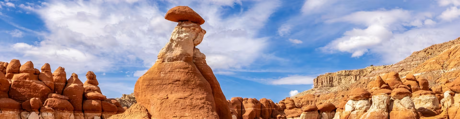
Scenic Road Trip Loops
Why it matters: The county’s scale is best understood from the driver’s seat, where you can watch terrain change mile by mile. A good loop gives you a mix of overlooks, short walks, and photo stops without overcommitting to one long hike. Practical tip: Start early to catch softer light and calmer roads, then keep a full tank when heading away from towns.
Sunrise and Sunset Viewpoints
Why it matters: The light in southern Utah can transform cliffs, mesas, and distant ridgelines in minutes. Planning your day around golden hour creates a natural rhythm and often delivers the best photos. Practical tip: Arrive before the peak moment, because parking and viewpoints can fill up quickly in popular areas.
Easy-to-Moderate Day Hikes
Why it matters: Shorter hikes are a high-value way to get beyond roadside scenery and feel the textures of the landscape, slickrock, sand, pine forest, or high desert. They also let you adapt to weather and energy levels. Practical tip: Carry more water than you think you need, and prioritize trails that match your heat tolerance and navigation comfort.
Stargazing and Night Photography
Why it matters: Remote stretches of Garfield County can deliver deep darkness and clear skies, which makes the night feel like a destination in itself. Even without a telescope, you can build an unforgettable evening around constellations and the Milky Way when conditions align. Practical tip: Bring a headlamp and warm layers, temperatures can drop quickly after sunset.
Small-Town Gateways and Local Stops
Why it matters: Towns in the region are more than a place to sleep, they are where you refuel, reset, and pick up local advice. A quick stop for coffee or a diner meal can turn into the best practical intel of the trip. Practical tip: Ask about road conditions and the day’s best viewpoints, locals often know which areas are windy, dusty, or crowded.
Scenic Pullouts and Short Walks
Why it matters: Not every memorable moment requires a long hike. Pullouts and short paths can deliver wide panoramas and intimate details like rock textures and desert plants. Practical tip: Keep a small daypack ready so you can hop out, walk a bit, and move on without losing momentum.
Photography Drives for Landscape Variety
Why it matters: The county’s visual range lets you shoot a full portfolio in one trip, from open desert to higher elevation forests depending on where you drive. This variety is ideal for travelers who want a flexible plan with lots of stops. Practical tip: Pack a lens cloth and protect your gear from dust, wind, and sudden weather changes.
Picnic Stops with a View
Why it matters: Eating outside turns a simple meal into a moment that matches the scale of the scenery. It also helps you manage time and budget on long driving days. Practical tip: Bring a small trash bag and pack out everything, remote areas depend on visitor care.
Plan a sunrise start, then spend the morning on a scenic drive with frequent pullouts and short walks. Midday is best for a longer lunch stop in a gateway town, plus a quick resupply of water and snacks for the afternoon. Finish with a sunset viewpoint, then shift to stargazing if skies are clear and you have a safe, legal place to park. This one-day approach works best when you accept that driving is part of the attraction in Garfield County.
Use day one to get oriented with scenic drives and easy hikes, then note which areas you want to revisit in better light. On day two, focus on a higher-effort hike or a longer route that takes you farther from the main corridor, then reward yourself with a relaxed dinner in town. If you have a third day, slow down, revisit your favorite viewpoint at a different time of day, add a picnic, and build in a buffer for weather, road conditions, and spontaneous stops. The goal is to travel like a local road-tripper, not a checklist runner.
Classic diner breakfast
Taste profile: Hearty and comforting, built for early starts and long drives. Ordering tip: Ask what is quickest if you are chasing sunrise, then grab coffee to go for the road.
Burgers and fries
Taste profile: Simple, satisfying, and easy to find when you need a reliable meal between drives. Ordering tip: If you are sharing, consider one larger meal and add a side, it is an easy way to manage budget.
Southwestern-style flavors
Taste profile: Often built around chiles, beans, and bold seasoning that pairs well with road-trip appetites. Ordering tip: If you are sensitive to spice, ask for mild options and add heat at the table if available.
BBQ-style plates
Taste profile: Smoky and filling, a good match for cooler evenings after a day outdoors. Ordering tip: If you are arriving late, call ahead when possible, some smaller places may have limited hours.
Fresh sandwiches for picnic days
Taste profile: Light, portable, and practical for viewpoint lunches. Ordering tip: Ask for sauces on the side so the bread stays intact during long drives.
Hot chocolate or warm drinks
Taste profile: Cozy and warming, especially after sunset when temperatures drop. Ordering tip: Pair it with a simple snack, then head out for stargazing with extra layers.
Getting around Garfield County is primarily a driving experience, and a rental car is the most straightforward option for most travelers. Walking works best for short town strolls, viewpoints, and trailheads, but distances between major sights are typically not walkable. Ride-sharing can be limited in remote areas, so plan as if you will be self-reliant for transport. For safety, keep water in the car, download offline maps when possible, and avoid pushing into remote roads if weather or visibility is poor.
Nearby scenic byways
Travel time: Varies by route and starting point. Primary reason to visit: A change of scenery and a chance to string multiple viewpoints into one day.
Neighboring counties in southern Utah
Travel time: Often a manageable drive depending on your base. Primary reason to visit: Add variety with different trail networks, towns, and landscapes.
Regional national park corridors
Travel time: Depends on which park area you choose. Primary reason to visit: Pair iconic destinations with quieter stretches back in Garfield County for a balanced trip.
High-elevation forest escapes
Travel time: Varies by elevation and road. Primary reason to visit: Cooler temperatures in warm months and a different ecosystem for hiking and picnics.
Do I need a car to explore the area?
Yes, driving is the most practical way to connect viewpoints, trailheads, and towns. Distances can be significant, and services may be limited once you leave main routes.
What is the best time of day for photos?
Sunrise and sunset usually deliver the most flattering light and deeper colors in the landscape. Midday can still work well for short hikes if you plan for sun exposure and hydration.
How many days should I plan for Garfield County?
One day works for a highlights loop focused on scenic drives and short stops. Two to three days lets you add longer hikes, revisit viewpoints in better light, and travel at a calmer pace.
Is it easy to find food and supplies during a road trip?
You can usually resupply in towns, but options may thin out on long stretches between communities. Keep snacks, water, and basic essentials in the car so you are not dependent on perfect timing.
What should I pack for a trip to Garfield County?
Bring layers, sun protection, and plenty of water, plus a basic first-aid kit for outdoor days. Offline maps and a car charger are also useful if you head into areas with limited signal.