Benagil Cave at High Tide: When (and When Not) to Go
How lunar cycles, tidal swell, and receding waters shape every visit to the Algarve's most iconic sea cavern
Benagil Cave, carved into the Algarve limestone cliffs roughly 3 kilometres east of Carvoeiro, is not a static landmark. Twice daily, the Atlantic tidal cycle transforms its interior from a broad golden beach fringed by calm shallows into a turbulent, wave-washed chamber where no kayak or small boat should attempt to land. Understanding that cycle is not optional for visitors planning a safe, rewarding entry in 2026.
How Does the Tidal Cycle Actually Work at Benagil?
The Algarve coastline experiences a semi-diurnal tidal pattern, meaning two high tides and two low tides occur within every 24-hour period. The difference in water level between high and low tide, known as the tidal range, averages roughly 2 to 3.5 metres along this stretch of coast, depending on the lunar phase. During spring tides, which follow each new moon and full moon by approximately 48 hours, that range widens considerably, pushing more water into confined coastal caverns like Benagil.
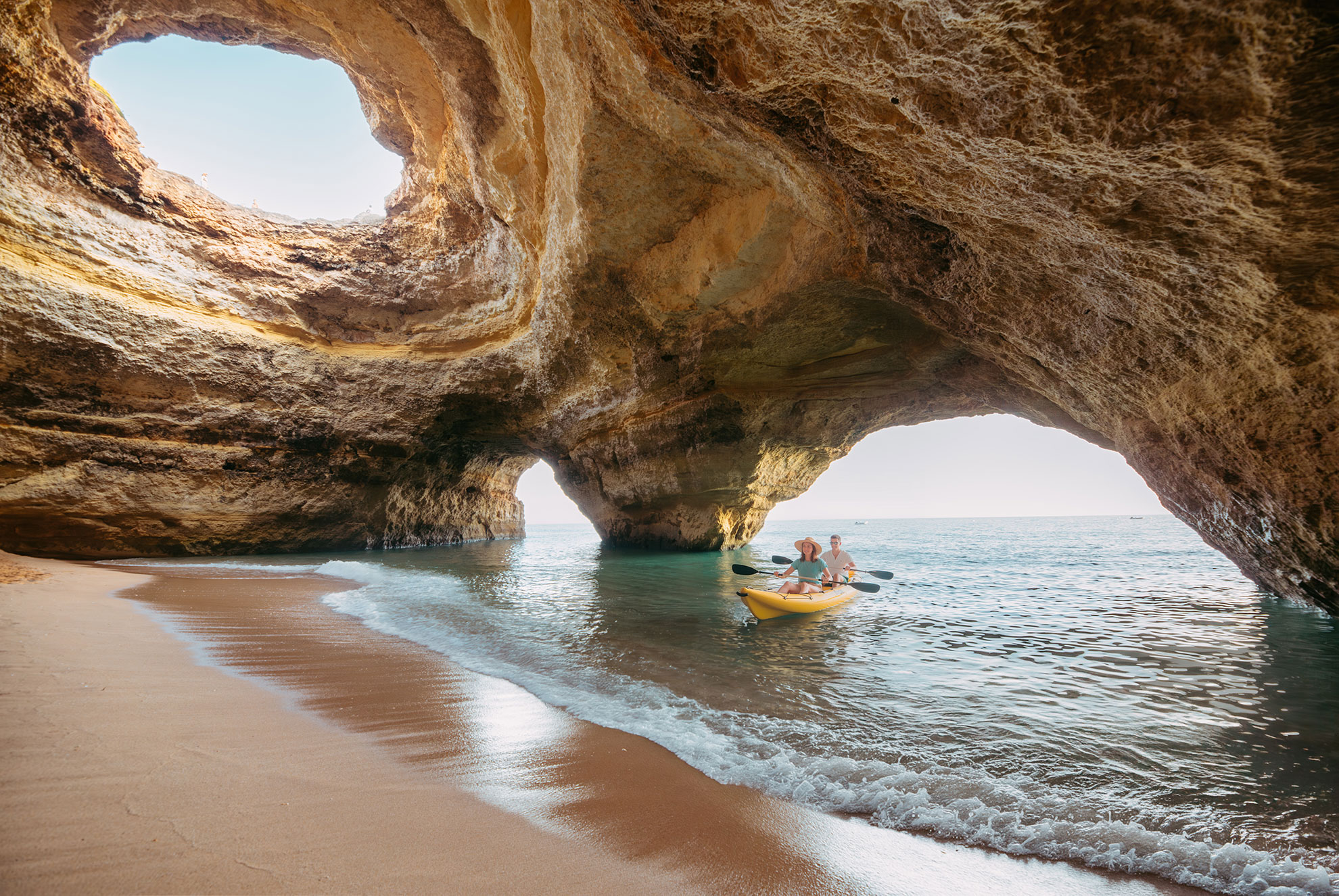
The cave itself sits at the base of a 50-metre-high cliff face and opens directly onto the Atlantic swell. Its mouth measures approximately 20 metres wide at the base, narrowing toward an arched ceiling. Tidal water enters not just through the main arch but also through two smaller lateral apertures, so the interior responds quickly to changes in sea state. A rising tide does not simply lift the water level uniformly; it also amplifies the shorebreak, the short, steep wave action that forms when ocean swells compress in shallow coastal zones.
"The cave does not care about your itinerary. It operates on a 12-hour-and-25-minute tidal clock set by the Moon, and every skipper on this coast knows to read that clock before departure." — local Benagil boat operator, 2024 season
Visitors planning a 2026 trip should consult the Tabela de Marés, Portugal's official tide prediction tables published by the Instituto Hidrográfico (IH). The IH station closest to Benagil is Portimão, located approximately 12 kilometres to the west, and its hourly predictions are accurate to within 15 minutes for Benagil conditions under normal atmospheric pressure. Significant low-pressure weather systems can raise actual water levels by 30 to 50 centimetres above predicted values, a variable that local guides factor into every departure decision.
What Changes Inside the Cave at Low Tide vs High Tide?
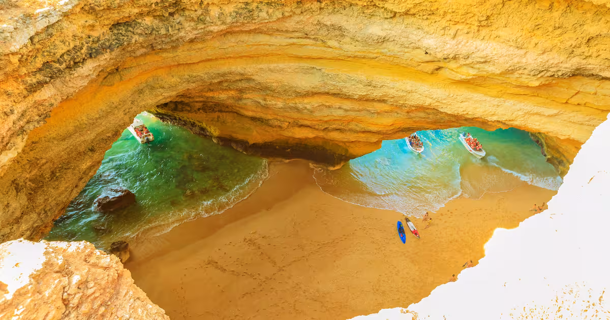
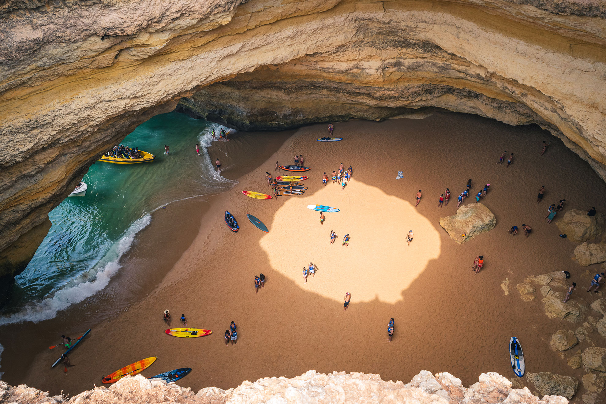
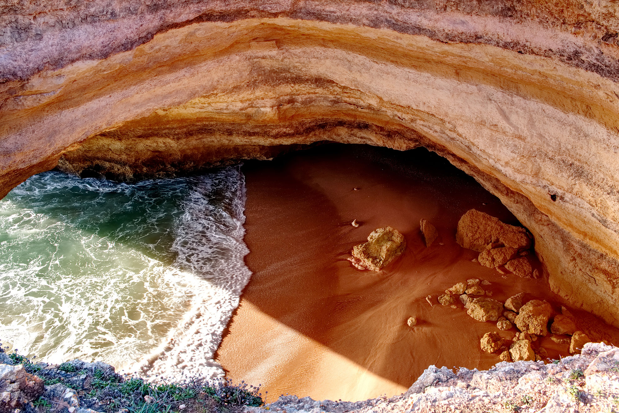
At low tide, the internal beach widens to roughly 15 to 20 metres across, exposing firm, compacted sand that allows kayakers to land cleanly and stand comfortably. The water depth at the mouth drops to between 0.4 and 0.8 metres at mean low water springs, so waves arrive with less energy and the shorebreak is manageable for experienced paddlers. Light enters through the circular skylight overhead, approximately 6 metres in diameter, and strikes the shallow water at a low angle, producing the amber and gold tones characteristic of Benagil photography at mid-morning low tide.
At high tide, the sand beach can shrink to a strip of less than 3 metres or disappear entirely beneath the surface. Wave sets wash across the entire floor of the cavern, and reflected swells bounce off the rear wall, creating chaotic cross-chop that makes controlled kayak entry extremely difficult. The water, now 1.5 to 2.5 metres deeper throughout the interior, reflects a deeper turquoise and teal off the limestone walls, and the visual drama increases noticeably. Photographers seeking that vivid blue-green palette sometimes specifically target the two-hour window around high water, provided sea conditions are calm overall.
"At high spring tide with a 1.5-metre swell running, you are looking at waves exploding against the back wall. The colours are spectacular through a zoom lens from a boat outside. You do not go in." — senior guide, Carvoeiro-based kayak operator
The transition period matters most. A falling tide, moving from high water toward low water over roughly six hours, progressively calms the interior while still maintaining relatively deep, clear water. The mid-tide falling window, typically two to three hours after the high-water peak, is widely considered the optimal entry period by operators running guided kayak tours out of Benagil Beach, which sits at the base of a narrow cliff-side stairway accessed via Praia de Benagil.
When Is It Unsafe to Enter Benagil Cave?
Entry to Benagil Cave is prohibited or strongly inadvisable under several overlapping conditions. The most common is the combination of high tide with swell height above 1.0 metre. The Instituto Português do Mar e da Atmosfera (IPMA) publishes daily wave forecasts for the Algarve coast; a swell of 1.2 metres at 10-second periods, a fairly common Atlantic pattern between October and April, is sufficient to fill the cave interior with dangerous surge even at mid-tide on a falling cycle.
Coastal surges, which occur when storm systems push large volumes of water toward the shore independently of the tidal cycle, are particularly hazardous between November and February. During these months, the Portuguese Maritime Authority (Autoridade Marítima Nacional) frequently issues restrictions on small craft operations in the Benagil coastal zone, which falls within the maritime jurisdiction of the Capitania do Porto de Portimão. Operators holding licences from that authority are legally required to comply with those restrictions, and reputable guided tour companies will cancel departures accordingly.
Swimmers attempting to reach the cave independently from Benagil Beach face additional risks. The beach itself is approximately 30 metres wide at low tide, fronted by a shore that generates powerful rip currents on rising tides, particularly in the gully between the main beach and the western rock stack. The direct swim to the cave entrance is roughly 200 metres from the beach access point, which is manageable in calm summer conditions but carries real hazard when tidal swell is running. Local rescue services, operating from the nearest station in Lagoa municipality, respond to incidents at this location every season.
ToursXplorer lists only licensed operators for all Benagil tours, and each operator shown on this platform has confirmed protocols for monitoring IPMA forecasts and IH tide data before departure. When conditions deteriorate, tours are rescheduled, not simply cancelled, with priority rebooking offered to affected guests.
What Is the Best Tide for Photography Inside Benagil Cave?
The circular skylight, which opens to the sky roughly 20 metres above the cave floor, creates a natural spotlight effect that changes character depending on both time of day and tidal height. The most-cited photographic conditions combine three factors: low-to-mid tide (exposing the maximum sand area), late morning solar angle (between 09:00 and 11:30 local time when the sun is positioned to send direct light through the aperture), and calm surface water (under 0.5 metres swell for clear reflections).
From May through August, the sun's declination places it at an angle that sends a direct beam through the skylight for approximately 90 minutes around 10:30 local time. This window coincides well with summer low tides, which in the Algarve tend to fall in the morning and early evening during the neap tide cycle. Checking the IH Portimão tide table for days when low water falls between 08:00 and 11:00 is a practical pre-trip step.
High tide does not preclude photography entirely. Boat tours that approach from outside the arch, including those departing from Albufeira Marina approximately 25 kilometres to the east and from Portimão harbour 12 kilometres to the west, can position at the cave mouth to capture the interior light even when entry is impossible. The flooded interior at high tide, with teal water filling the frame from arch to skylight, produces a distinctly different but equally compelling image that wide-angle drone operators and boat-based photographers actively seek. ToursXplorer features multiple departure points precisely to offer flexibility when tidal windows at Benagil itself are unfavourable.
Planning Your Visit: Practical Steps for 2026
A reliable pre-visit checklist covers four sources. First, the IH tide tables for Portimão station, available at hidrografico.pt, give hourly predictions for the year. Second, the IPMA 10-day maritime forecast for the Algarve coastal zone provides swell height and period data. Third, the Capitania do Porto de Portimão publishes navigational notices (avisos à navegação) when restrictions apply to the Benagil coastal area, identifiable by the coordinates 37°05'N 08°26'W. Fourth, the specific operator running your chosen tour will communicate go or no-go decisions, typically the evening before departure.
For kayak tours launching directly from Benagil Beach, the parking situation deserves mention. The access road, a single-lane track descending from the EN125 national road, has very limited space and routinely fills before 09:00 in July and August. Early morning departures timed to a falling tide window are therefore doubly advantageous: they align with better tidal conditions and with lower road and beach congestion.
Visitors booking sunrise kayak departures should note that the cave interior, while visually striking at first light, receives no direct skylight illumination until the sun rises sufficiently above the cliff horizon, typically around 07:45 in June and 08:30 in October. The pre-sunrise window offers atmospheric low-light photography and very calm sea conditions, as thermal winds and Atlantic sea breezes have not yet developed, but the famous sunbeam effect through the skylight requires patience until mid-morning.
Kayak Tours to Benagil Cave
Sunset and SUP Tours
Boat Tours from Portimão and the Algarve Coast
Check live availability for Benagil cave tours on ToursXplorer and filter by departure point to match the tidal window that suits your travel dates.
Click hereThe Cave as a Living Environment: Adapting to the Sea's Schedule
Benagil Cave is frequently described in tourism materials as one of the most visited sea caves in Europe, a designation supported by the volume of boat and kayak traffic recorded along the Lagoa municipality coastline each summer. What those descriptions rarely convey is that the cave's accessibility is genuinely variable on a six-hour cycle, and that the visitor who arrives without checking tide data is, in practical terms, leaving the quality and safety of the experience to chance.
The geological context reinforces this point. The cave formed through the erosion of biocalcarenite limestone, a sedimentary rock composed largely of cemented marine organisms deposited during the Miocene epoch roughly 5 to 23 million years ago. The same wave action that created the cave continues to reshape it. The skylight aperture, for instance, formed when the original cave ceiling collapsed under sustained hydraulic pressure from above-water wave action, a process that still operates during major Atlantic storm events. The cave is not finished forming.
ToursXplorer presents the full range of Benagil tour formats on a single platform precisely because no single departure point or vessel type suits all tidal conditions. Kayak tours entering the interior require the most precise tidal timing. Boat tours observing from outside the arch are viable across a wider range of conditions. Catamaran tours from Albufeira provide an accessible introduction to the cave's exterior even when entry is impossible. Matching the tour format to the day's oceanic conditions, rather than selecting a tour based on price or duration alone, is the practical approach to this coastline.
Seasonal Patterns: How Conditions Shift Through the Year
The Algarve's maritime climate divides broadly into a calm season running from late April through early October and a rougher Atlantic season from November through March. Average swell heights at the mouth of Benagil Cave, based on IPMA hindcast data for the Faro coastal zone, are 0.5 to 1.0 metres in July and August, rising to 2.0 to 3.5 metres during January and February storm periods. Cave entry by kayak is regularly possible throughout the calm season but becomes genuinely hazardous during the winter period even at low tide, when residual swell energy is still sufficient to generate dangerous surge inside the cavern.
September and October represent a transitional period that experienced guides consider underrated. Swell heights are typically moderate, averaging 0.8 to 1.5 metres, crowds on the Benagil access road drop substantially after the school holiday period ends in early September, and the lower solar angle begins to produce longer, warmer light through the skylight aperture later into the morning. Water temperature, which peaks at approximately 22 to 23 degrees Celsius in late August, remains above 20 degrees Celsius through October, so wetsuit requirements for kayak participants are less pressing than in spring.
Spring tides occurring near the March and September equinoxes produce the largest tidal ranges of the year, sometimes exceeding 3.5 metres at Portimão. These periods are worth noting specifically in pre-trip tide chart analysis, as the combination of large range and residual Atlantic swell can render Benagil Cave inaccessible for extended periods even during otherwise favourable seasons. Booking a flexible tour format through ToursXplorer for equinox-period travel is a practical hedge against these conditions.
Browse all Benagil kayak and boat tours on ToursXplorer to find departure times aligned with the best mid-tide falling window for your chosen date.
Frequently Asked Questions
Entry to Benagil Cave is significantly restricted at high tide. When the tidal height combines with swell above 1.0 metre, the internal beach is largely submerged and wave action inside the cavern prevents safe kayak landing. Boat tours can still approach the arch from outside for photography. The mid-tide falling window, roughly two to three hours after high water, is generally the first viable entry period.
The optimal photography conditions combine low-to-mid tide, which exposes the full sand beach and provides a clear foreground, with a late-morning solar angle between 09:00 and 11:30 local time when sunlight projects directly through the 6-metre skylight aperture. In summer months, checking IH Portimão tide tables for low water falling between 08:00 and 11:00 helps identify the best dates.
Swimming to the cave is physically possible from Benagil Beach, approximately 200 metres from the access point to the cave entrance, during calm summer conditions at or near low tide. However, rip currents form in the gully between the main beach and the western rock stack on rising tides, and local rescue services respond to incidents here every season. Joining a guided kayak tour is the safer alternative.
Use the Instituto Hidrográfico tide tables for the Portimão station, available at hidrografico.pt, which provide hourly predictions accurate to within 15 minutes for Benagil under normal conditions. Cross-reference with the IPMA maritime forecast for Algarve swell height and period. Your tour operator will also confirm go or no-go conditions, typically the evening before departure.
There is no formal seasonal closure, but the Portuguese Maritime Authority issues small craft restrictions for the Benagil coastal zone during storm periods, particularly between November and February. When swell exceeds roughly 1.5 metres or when Capitania do Porto de Portimão navigational notices apply, licensed operators are legally required to suspend departures. This effectively closes the cave to guided tours until conditions improve.
Kayak tours allow entry and landing inside the cave on the internal beach, but require the most precise tidal timing and are unsuitable in swell above 1.0 to 1.2 metres. Boat tours can observe the cave from outside the arch across a wider range of conditions and are accessible to visitors who do not paddle. Private boat charters offer the most flexibility because the skipper can time the approach to the exact tidal window.