Pico do Areeiro to Pico Ruivo Hike: The Complete PR1 Trail Guide
Everything you need to know to tackle Madeira's most iconic mountain trail, from sunrise conditions to tunnel safety and summit views.
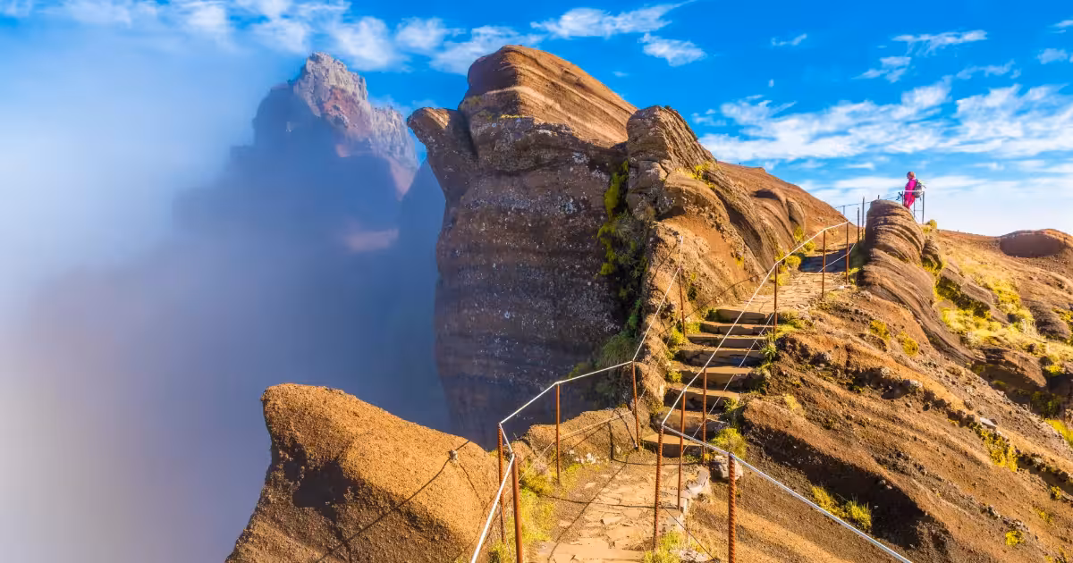
The PR1 trail connecting Pico do Areeiro (1,818 m) to Pico Ruivo (1,862 m), the highest peak in Madeira, covers approximately 9.7 kilometres one way and takes between 3 and 5 hours depending on pace. The route crosses three major peaks, passes through carved rock tunnels, and offers some of the most dramatic ridge-walking scenery on any Atlantic island. It is classified as a moderately difficult trail by the Madeira Regional Secretariat of the Environment.
What is the PR1 Trail and Why is it Considered Madeira's Best Hike?
The PR1 is a waymarked hiking trail in Madeira's central mountain range, officially designated by the Madeira Regional Government. Its full name is Vereda do Areeiro, and it connects Pico do Areeiro (1,818 metres above sea level) with Pico Ruivo (1,862 metres above sea level), the highest point on the island. Along the route, hikers pass over Pico das Torres (1,851 m) and through sections of rugged volcanic terrain that has been shaped by centuries of Atlantic weather and geological activity.
The trail is part of the Madeira Natural Park, a protected area that covers roughly 67 percent of the island's interior. Sections of the central massif fall within the Madeira Laurisilva, a UNESCO World Heritage Site inscribed in 1999, recognised as one of the best-preserved laurel forest ecosystems in the world. The PR1 does not pass directly through the laurel forest canopy at altitude, but the surrounding landscape reflects the ecological importance of the region.
The stairways and metal railings carved into the volcanic rock faces along the PR1 were installed progressively from the 1960s onward, making a previously near-inaccessible ridge traversable for recreational hikers.
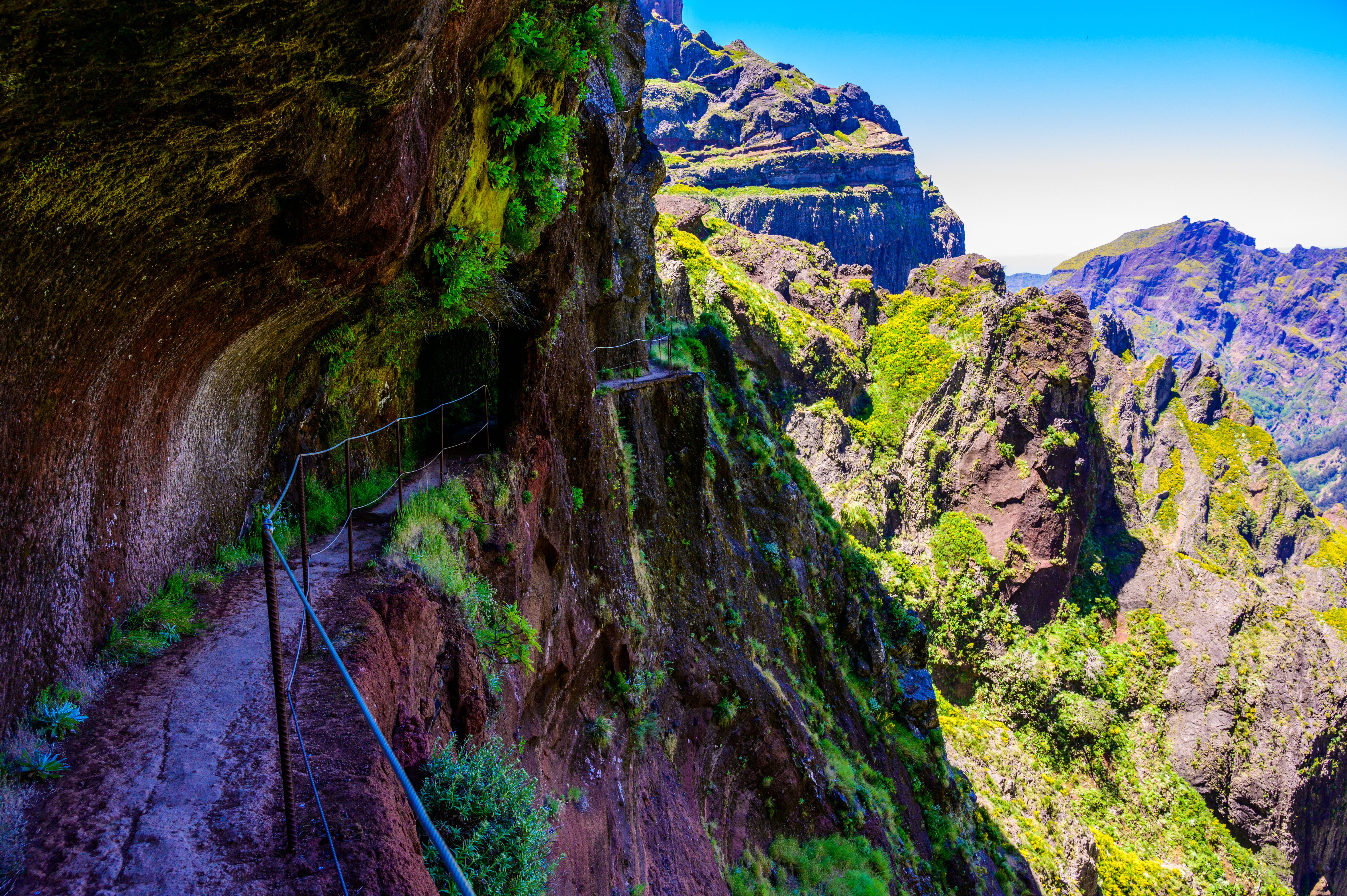
What distinguishes PR1 from other Madeira hiking trails is its combination of engineered mountain infrastructure and raw landscape. The route includes several pedestrian tunnels cut through basalt rock, some exceeding 100 metres in length, as well as exposed walkways above vertical drops with chain and railing supports. This makes the trail physically demanding in sections, while remaining accessible to fit hikers without technical climbing experience.
How Difficult is the Pico do Areeiro to Pico Ruivo Hike?
The PR1 trail is classified as moderately difficult (Level 3 out of 5) by the Madeira Regional Secretariat of the Environment. The total one-way distance from Pico do Areeiro to Pico Ruivo is approximately 9.7 kilometres, with a cumulative elevation gain of around 700 metres and an elevation loss of roughly 500 metres. Most hikers completing the trail in the Areeiro-to-Ruivo direction (west to east) will find the first third the most demanding, particularly the descent from Pico do Areeiro and the subsequent ascent toward Pico das Torres.
Estimated walking time for the full one-way route is 3 to 5 hours for fit adults at a moderate pace, not including stops at viewpoints or the Abrigo do Pico Ruivo mountain refuge at the summit. If you plan to return the same way on foot, budget 6 to 9 hours total and carry at least 2 litres of water per person. There are no reliable water sources along the trail.
The trail is suitable for children over approximately 10 years old who are comfortable on uneven terrain, but it is not appropriate for pushchairs, wheelchairs, or hikers with a fear of heights due to exposed ridgeline sections with steep drops on both sides. Proper footwear is essential: trail running shoes at minimum, though ankle-supporting hiking boots are recommended for the rocky and sometimes wet stairway sections.
Mountain weather on Madeira's central peaks changes rapidly. Clear skies at the trailhead can give way to dense cloud and reduced visibility within 20 minutes. Checking forecasts for 1,800 metres elevation, not sea-level Funchal conditions, is one of the most important things a hiker can do before setting out.
For the tunnel sections, a headlamp or torch is not optional. The longest tunnel on the route runs for approximately 110 metres through solid rock with no artificial lighting. Carrying a waterproof layer is equally important year-round, as temperatures at 1,800 metres average 5 to 8 degrees Celsius cooler than at sea level and rainfall is significantly higher.
When is the Best Time to Hike Pico Ruivo in Madeira?
The trail is accessible year-round, but conditions vary considerably by season. The months of April through June and September through October generally offer the most stable weather windows, with longer daylight hours in summer reducing the need to start in darkness. July and August bring more reliable sunshine but also significantly more foot traffic, with the car park at Pico do Areeiro filling by 07:00 on clear mornings.
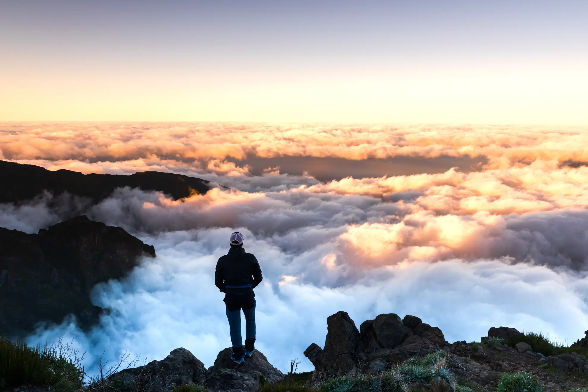
Sunrise hiking on the PR1 has grown substantially in popularity, particularly for photography. Civil twilight begins around 06:15 in midsummer and as late as 07:30 in December, and the phenomenon of cloud inversion, where a flat sea of cloud sits below the peaks while the summits remain in clear air, is most common in the cooler months between October and March. On these mornings, the ridge between Areeiro and Ruivo appears to rise from a white ocean, with only the highest peaks of central Madeira visible above the clouds.
Winter hiking is entirely feasible and can offer the most dramatic atmospheric conditions, but trails may carry ice and frost above 1,600 metres from December to February. The Regional Government occasionally closes sections of the PR1 after severe weather events, and these closures are announced on the Madeira Natural Park website. Hikers should always verify trail status before departing, particularly following storms.
The Abrigo do Pico Ruivo, a government-operated mountain refuge and shelter at the summit of Pico Ruivo, provides basic refreshments seasonally. Opening hours and seasonal closures vary, so travellers should not rely on the refuge as a primary food or water source.
Is the PR1 Trail Worth It, and What Should You Expect at the Summit?
Pico Ruivo's summit sits at 1,862 metres and on a clear day offers an unobstructed 360-degree panorama across Madeira's central massif, the north coast cliffs, and on exceptional days, the neighbouring island of Porto Santo approximately 43 kilometres to the northeast. The Pico das Torres, at 1,851 metres, provides a secondary viewpoint roughly midway along the route and is often less crowded than the main summit.
The trail passes through vegetation zones that shift noticeably with altitude. Below the cloud base, hikers encounter Erica arborea (tree heath) and Pteridium aquilinum (bracken fern). Higher sections support specialist high-altitude flora including Echium candicans (Pride of Madeira) on exposed rocky outcrops. The endemic Madeiran chaffinch (Fringilla coelebs maderensis) is frequently sighted along the ridge, and Buteo buteo harterti, the Madeiran buzzard, circles thermals above the peaks throughout the year.
ToursXplorer lists guided and self-guided options for this trail that address the main planning challenges, including transport to the trailhead, navigation support on the more exposed sections, and return logistics. For first-time visitors unfamiliar with Madeira's mountain weather patterns, starting with a guided option is a practical way to build confidence before attempting the trail independently.
Responsible use of the PR1 trail means staying on marked paths, carrying out all waste, and avoiding the use of drones within the Madeira Natural Park boundaries without prior authorisation from the Madeira Regional Government. The trail surface in several sections is irreplaceable volcanic rock infrastructure, and shortcuts across switchbacks cause erosion on the steep southern slopes.
Guided and Self-Guided Tours for the Pico do Areeiro to Pico Ruivo Hike
Ready to hike Madeira's highest peaks? Browse guided sunrise tours and self-guided options on ToursXplorer and secure your spot before the car park fills.
Click herePlanning Your Hike: Practical Checklist and Safety Advice
Getting the logistics right before arriving at Pico do Areeiro significantly improves the experience. The car park at the summit of Areeiro is accessible via the ER202 road from Poiso, which connects to Funchal approximately 20 kilometres to the south. Public transport to the trailhead is limited, making a hire car or organised tour pickup the two main options for most visitors.
Key items to carry on the PR1 trail: a headlamp with fresh batteries (mandatory for tunnels), at least 2 litres of water per person, a waterproof layer and insulating mid-layer regardless of sea-level conditions, high-energy snacks, a fully charged phone with an offline map downloaded (IGN or Wikiloc coverage is available), and sunscreen for exposed ridge sections above the cloud layer where UV intensity increases substantially.
ToursXplorer's listings for the PR1 route include options with hotel pickup from Funchal, which removes the logistical challenge of driving a narrow mountain road in darkness before a sunrise start. For travellers planning an independent attempt, the Regional Government of Madeira's official nature portal publishes daily trail condition reports and closure notices for the Madeira Natural Park.
Sustainable hiking on the PR1 means staying on the marked trail at all times, not picking any plant material (protected under Madeira Regional Decree 28/87/M), carrying out all waste including organic material such as fruit peels, and keeping noise levels low in the early morning hours when bird activity along the ridge is highest. The trail receives an estimated 150,000 to 200,000 visitors annually, and cumulative impact from off-trail movement is a documented concern for park management.
Getting the Most from a Sunrise Start on the PR1 Trail
Arriving at Pico do Areeiro before civil twilight (roughly 30 minutes before sunrise) gives hikers two distinct advantages. The car park is significantly less crowded, and the light conditions on the ridge during the blue hour and golden hour provide the most visually distinctive photography opportunities, particularly for capturing cloud inversions over the central valley toward Ribeira Brava and Câmara de Lobos on the south coast.
For the first kilometre from the Areeiro trailhead, the path descends steeply via stone stairs with chain and railing support. In darkness, this section requires careful footing even with a headlamp. Pace is naturally slower than in daylight, which is worth factoring into timing calculations. Most hikers aim to reach the viewpoint at Ninho da Manta, approximately 1.5 kilometres into the route, around the moment of actual sunrise for clear views east toward Pico Ruivo and the ridgeline ahead.
Weather forecasting resources specifically calibrated for Madeira's mountain elevations include Meteoblue's mountain forecast for Pico Ruivo and the Instituto Português do Mar e da Atmosfera (IPMA) daily bulletins. Sea-level forecasts for Funchal are not a reliable indicator of conditions at 1,800 metres, where cloud, wind, and temperature can differ substantially within the same hour.
Frequently Asked Questions
The one-way distance is approximately 9.7 kilometres with a cumulative elevation gain of around 700 metres. Most fit adults complete the route in 3 to 5 hours at a moderate pace. A return on foot takes 6 to 9 hours total. Many hikers arrange a taxi or tour pickup at Pico Ruivo to avoid retracing the full route.
The PR1 is rated moderately difficult (Level 3 of 5) by the Madeira Regional Secretariat of the Environment. The trail involves steep stone staircases, unlit rock tunnels up to 110 metres long, and exposed ridge sections with steep drops. It is not suitable for pushchairs or hikers with a significant fear of heights, but does not require technical climbing skills.
April to June and September to October offer the most stable weather. Sunrise hikes are popular year-round, with cloud inversions most frequent from October to March. Summer months (July to August) bring reliable sunshine but heavy crowds, with the Areeiro car park often full before 07:00. Winter trails may carry ice above 1,600 metres.
A guide is not mandatory but is recommended for first-time visitors unfamiliar with Madeira's rapidly changing mountain weather and trail navigation. Guided tours handle transport logistics, provide safety briefings for tunnel sections, and offer ecological context along the route. Self-guided options with route materials are also available for experienced hikers.
Essential items include a headlamp with spare batteries (tunnels have no lighting), at least 2 litres of water per person, a waterproof and insulating layer, ankle-supporting hiking boots, high-energy snacks, and sunscreen. Temperatures at 1,800 metres average 5 to 8 degrees Celsius cooler than Funchal at sea level, and conditions can change within minutes.
The PR1 connects Madeira's third and first highest peaks across 9.7 kilometres of volcanic ridge terrain within the Madeira Natural Park. On a clear day, the Pico Ruivo summit provides a 360-degree panorama including the north coast and, on exceptional days, Porto Santo island 43 kilometres away. For hikers comfortable with the difficulty level, it represents the most scenically varied trail on the island.