Seven Hanging Valleys Trail: The Complete 2026 Hiking Guide
Twelve kilometres of karstic clifftops, fossil-rich limestone, and turquoise inlets between Praia da Marinha and Praia de Vale Centeanes.
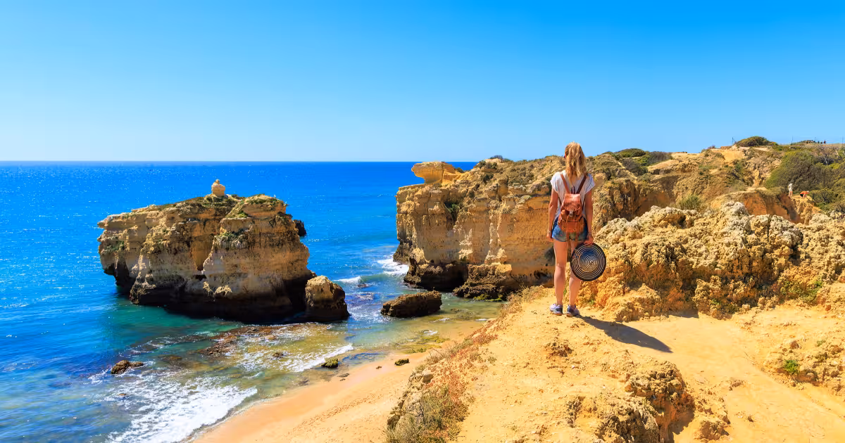
The Seven Hanging Valleys trail runs 6 kilometres one way, 12 kilometres out and back, between Praia da Marinha and Praia de Vale Centeanes along the Algarve's Barlavento coast. Carved into Jurassic-era limestone by centuries of differential erosion, the route passes sea caves, natural arches, and a sequence of valleys suspended above the Atlantic. It is widely regarded as one of southern Europe's most visually rewarding coastal walks.
Where does the Seven Hanging Valleys trail start and how long is the route?
The official trailhead sits at Praia da Marinha, roughly 4 kilometres east of Carvoeiro on the EN125-1 road. A free car park at Praia da Marinha serves most hikers arriving by car, while local taxis and seasonal shuttle services connect the beach to Lagoa and Carvoeiro town. The western terminus is Praia de Vale Centeanes, a small sheltered beach 2 kilometres west of Carvoeiro. Most walkers complete the route as an out-and-back of approximately 12 kilometres, returning to their starting point at Praia da Marinha. A one-way point-to-point crossing of 6 kilometres takes between two and three hours at a comfortable pace, allowing for stops at viewpoints. The full out-and-back typically requires four to five hours.
The path follows Percurso dos Sete Vales Suspensos, officially designated as a local interest trail by the Lagoa municipality. Waymarking is generally reliable: look for red-and-yellow painted blazes on rocks and wooden posts. The route is linear rather than circular, so hikers planning a one-way crossing should arrange return transport in advance. Taxis can be booked from Carvoeiro or Lagoa, and in summer months some tour operators run drop-off and pick-up services coordinated with the walking schedule.
What is the geology behind the hanging valleys phenomenon?
The name refers to a specific geomorphological feature: hanging valleys form when a main valley erodes or retreats faster than the smaller tributary valleys feeding into it. Along this stretch of the Algarve, marine erosion has cut the cliff face back at a rate faster than the small seasonal streams draining the inland plateau could deepen their channels. The result is a series of valley floors that appear to be suspended, or hanging, above the sea, with no river mouth at beach level. The streams that once reached the Atlantic now terminate at sheer drops of up to 40 metres, their water cascading or simply disappearing into the karstic rock below.
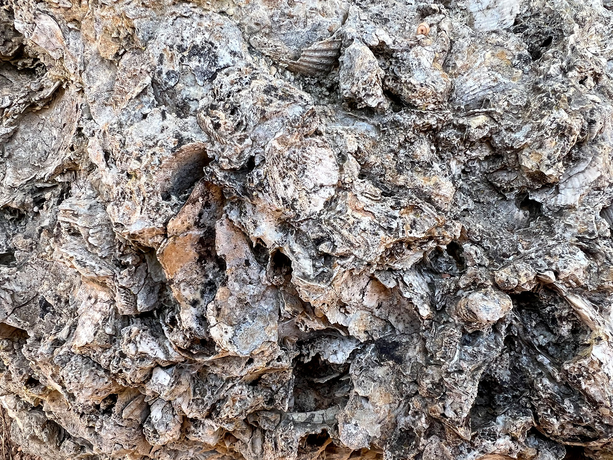
The limestone here dates to the Jurassic period, roughly 150 million years ago, and retains visible marine fossils including bivalves, echinoderms, and gastropods embedded in the cliff faces at eye level along sections of the path.
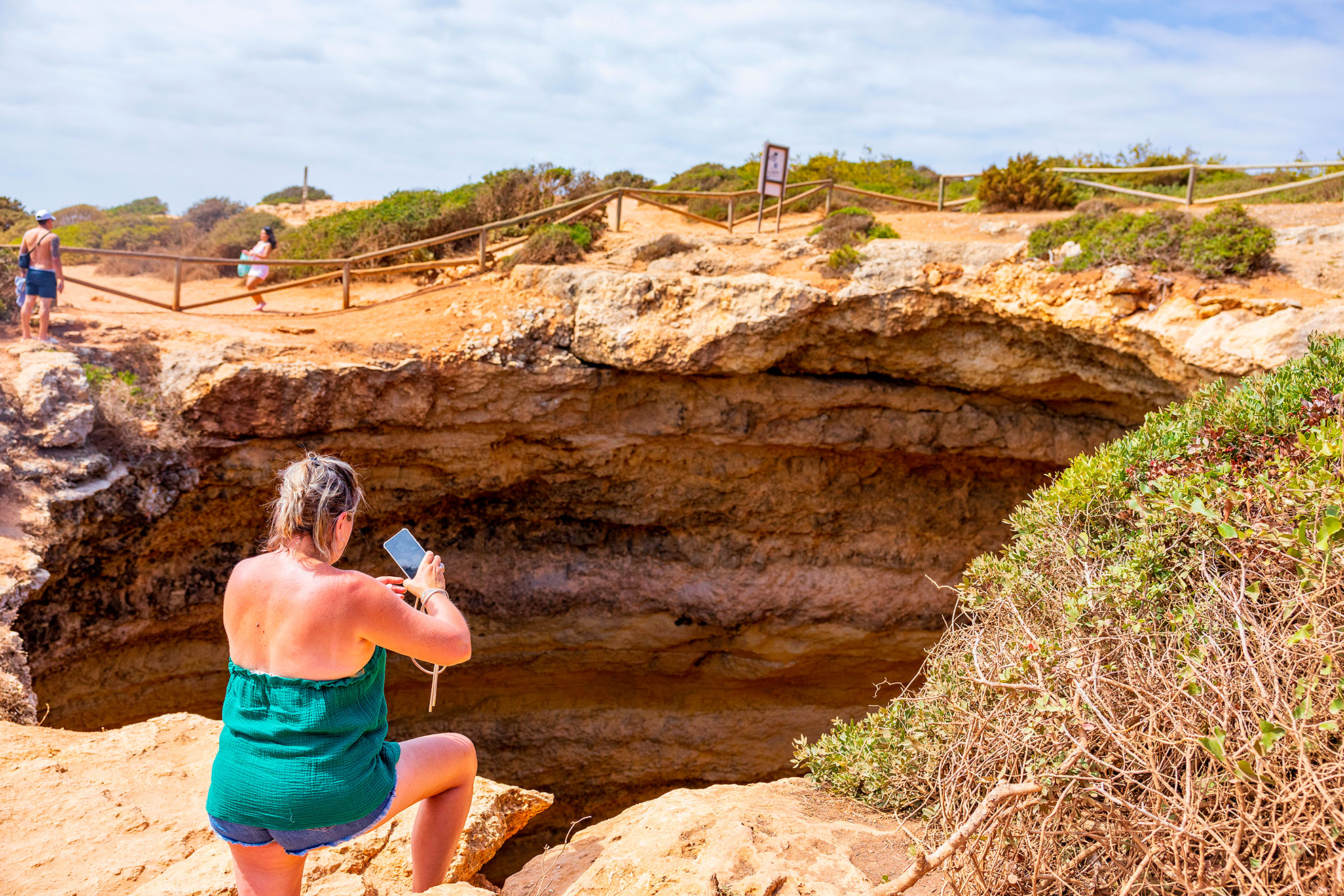
The rock itself is a bioclastic limestone, formed from compressed shells and organic sediment on an ancient seabed. Rainwater, slightly acidic due to dissolved carbon dioxide, has dissolved the limestone over millennia to produce the karstic landscape visible today: blowholes, natural arches, sea stacks, and the celebrated Benagil Cave with its famous domed ceiling and oculus opening to the sky. Walking the trail, hikers pass directly above this cave system, and the viewpoint above the Benagil
What are the key landmarks along the trail?
Starting from Praia da Marinha, the first significant viewpoint appears within the opening 500 metres: a series of natural arches and sea stacks at the eastern end of the beach, accessible via a short descent on a rocky path. The arches here are structurally distinct, with flat-topped limestone platforms extending over the water. Continuing westward, the path passes above Praia da Mesquita, a pocket beach accessible only by sea or by a steep scramble. The beach itself is rarely visited on foot, which preserves its quiet character and makes it a notable sighting from the clifftop.
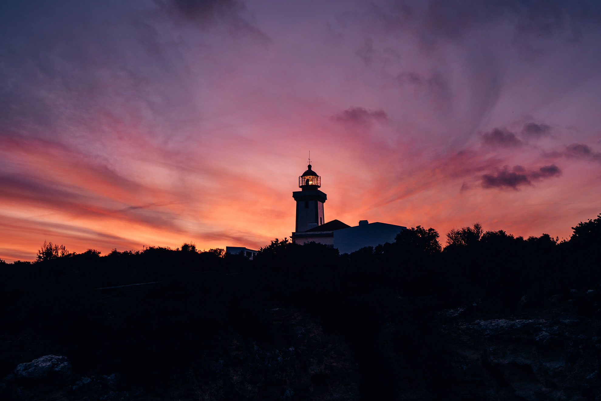
At roughly the midpoint of the one-way route, the path approaches the Benagil area. The viewpoint above the cave sits a short walk off the main trail on a marked spur. From here, the circular oculus in the cave ceiling, approximately 10 metres in diameter, frames the Benagil beach sand below and the cave's turquoise pool. The view is disorienting and geometrically precise in a way that photographs rarely capture at scale. Continuing west, the Alfanzina Lighthouse (Farol da Alfanzina), operational since 1919 and standing at a height of 25 metres, appears on the headland above Praia de Caneiros. The lighthouse is not open to the public but is clearly visible from the trail and marks the approach to the western half of the route. The final stretch descends toward Praia de Vale Centeanes, a beach sheltered by flanking cliffs and popular with local families.
On clear days, the pine-scented breeze from the interior scrubland mixes with the salt air at the clifftop, and the colour of the water below shifts from deep cobalt in open water to translucent jade over the shallow sandy floors of the enclosed coves.
Notable wildlife along the route includes Cory's shearwater (Calonectris borealis), which nests in cliff cavities along this coast between April and October, and yellow-legged gull (Larus michahellis), a constant presence at every viewpoint. In spring, the clifftop scrub produces sea lavender (Limonium sp.) and rock samphire (Crithmum maritimum), identifiable by their yellow-green flower clusters and aromatic smell when brushed underfoot.
How difficult is the Seven Hanging Valleys trail for beginners?
The trail is classified as moderate by the Lagoa municipality. Total elevation gain over the one-way 6-kilometre route is approximately 200 metres, distributed across several short climbs and descents rather than a single sustained ascent. The path surface alternates between compacted earth, exposed limestone rock, and wooden boardwalk sections installed to protect the most fragile cliff-edge areas. There are no technical climbing sections, but some passages require placing hands on rock for balance, particularly near viewpoints where the path narrows.
For beginners, the primary challenges are cumulative distance, sun exposure, and uneven footing rather than gradient. The route has almost no natural shade between Praia da Marinha and the Benagil area. Hikers should carry a minimum of 1.5 litres of water per person, wear a hat and sunscreen, and wear closed-toe shoes with grip. Sandals and flip-flops are unsuitable. Sturdy trail trainers are adequate for the majority of walkers; hiking boots are recommended for those who prefer ankle support on uneven ground. Children above the age of approximately 8 can typically manage the route, provided they are comfortable walking on rock and remain supervised near cliff edges.
ToursXplorer lists guided options for this trail for travellers who prefer structured support, an expert-led pace, and contextual information about the geology and ecology en route. Guided groups also benefit from pre-arranged logistics, including transport to and from the trailhead.
What is the best time to hike the Seven Hanging Valleys trail in 2026?
The Algarve's climate makes this trail walkable year-round, but conditions vary significantly by season. Summer months, particularly July and August, bring midday temperatures exceeding 35 degrees Celsius on exposed clifftops. Starting before 08:00 or after 17:00 reduces heat exposure substantially and also places walkers on the path during the best light for photography. The low-angle morning and late-afternoon sun accentuates the texture of the limestone and deepens the colour contrast between the amber cliffs and the sea below.
Spring, specifically March to May, offers mild temperatures between 17 and 24 degrees, lower visitor numbers, and wildflowers on the clifftop scrub. Autumn, from September to November, provides similarly comfortable conditions. Winter walking is feasible and often underrated: rainfall keeps the path clear of dust and the ocean is more energetic, producing visible spray at the base of the cliffs. However, wet limestone becomes slippery, so grip footwear is particularly important between November and February. Sunrise at Praia da Marinha in midsummer occurs around 06:30 local time, making an early start logistically straightforward.
What safety and sustainability rules apply to the trail in 2026?
The limestone cliffs along the Sete Vales Suspensos route are geologically active. Rock falls are a documented hazard, and sections of clifftop have collapsed in recent years following periods of heavy rainfall. Wooden fencing and rope barriers installed by the Lagoa municipality mark the safe viewing perimeter at all major viewpoints. Hikers must remain behind these barriers at all times. Stepping beyond the fences to reach a better photograph position has been responsible for fatalities on this coastline, including documented incidents in 2019 and 2022.
The fragile limestone ecosystem is also sensitive to foot traffic. Hikers should stay on marked paths and avoid stepping onto the low clifftop scrub, which stabilises the soil and prevents accelerated erosion. Wild camping and fires are prohibited throughout the route. Dogs are permitted but must be kept on a lead in proximity to cliff edges and nesting areas. Rubbish bins are available at Praia da Marinha and at the Benagil beach access point but are absent along the trail itself. Carry out all waste. ToursXplorer's guided walks on this route brief participants on these regulations before departure, and guides are trained to intervene if clients approach unsafe areas.
Guided and Private Tours on the Seven Hanging Valleys Route
Ready to walk the Seven Hanging Valleys trail with expert guidance? Browse all Algarve walking tours on ToursXplorer and find the format that suits your group, from private day trips to e-bike adventures.
Click hereWhat to Bring: Seven Hanging Valleys Packing List for 2026
The following kit list reflects the specific conditions of this route rather than a generic hiking checklist:
Footwear: Closed-toe trail trainers with a rubber grip sole are the minimum requirement. Hiking boots with ankle support are preferable for those who walk infrequently on uneven terrain. No sandals, flip-flops, or canvas shoes.
Water: A minimum of 1.5 litres per person for the one-way route in warm weather. No reliable water sources exist between the Praia da Marinha car park and Praia de Vale Centeanes.
Sun protection: Sunscreen (minimum SPF 30), a wide-brimmed hat, and sunglasses. The clifftop path offers almost no shade for the majority of its length.
Navigation: Download the trail to a phone-based GPS app (Wikiloc and AllTrails both carry verified tracks for Percurso dos Sete Vales Suspensos) before departing. Mobile signal is intermittent along the clifftop sections.
Snacks: No food vendors operate along the trail. A light lunch or energy snacks are necessary for the full out-and-back. Praia da Marinha has a seasonal beach bar at the car park level.
Camera or phone charged: Numerous viewpoints offer compositions that require little photographic skill to record effectively. The path above Benagil Cave in particular rewards anyone who pauses for 60 seconds with a perspective that no boat tour replicates.
ToursXplorer's guided options on this route include a pre-departure briefing that covers all of the above in detail, with guides carrying first-aid kits and emergency contact protocols as standard.
Frequently Asked Questions
The one-way route from Praia da Marinha to Praia de Vale Centeanes covers 6 kilometres and takes between two and three hours at a comfortable walking pace with viewpoint stops. The full out-and-back of 12 kilometres requires four to five hours. Add extra time in summer when heat slows the pace.
The most commonly used trailhead is at Praia da Marinha, approximately 4 kilometres east of Carvoeiro on the EN125-1 road. A free car park serves the beach. The western end of the trail terminates at Praia de Vale Centeanes, 2 kilometres west of Carvoeiro. One-way hikers should arrange return transport in advance.
The trail is classified as moderate. Total elevation gain over the 6-kilometre one-way route is approximately 200 metres, spread across multiple short climbs rather than a single steep ascent. The main challenges are heat, sun exposure, and uneven limestone footing. Sturdy closed-toe shoes, water, and sun protection make the route accessible to most reasonably fit adults.
Spring (March to May) and autumn (September to November) offer the best combination of mild temperatures and lower visitor numbers. In summer, start before 08:00 or after 17:00 to avoid midday heat above 35 degrees Celsius. Winter is walkable but wet limestone becomes slippery, so grip footwear is essential.
Yes. A short marked spur off the main trail leads to a viewpoint directly above the Benagil Cave oculus, an opening approximately 10 metres in diameter in the cave ceiling. The top-down view into the cave interior and its turquoise pool is one of the trail's most distinctive perspectives and is not accessible from sea-level boat tours.
Dogs are permitted on the trail but must be kept on a lead at all times, particularly near cliff edges and in areas with nesting seabirds such as Cory's shearwater, which nests in cliff cavities between April and October. Owners are responsible for carrying out any waste, as no bins are located along the trail between the two beach endpoints.